 From the NSIDC, Sea ice reaches it’s annual minimum extent growing by 370,000 square miles over 2007. An area 1 1/2 times the size of Texas. The recovery is 220,000 sq miles above last year alone yet the NSIDC claims below that the scientists don’t consider this a recovery.
They cite younger thinner ice again and a lower level than the 30 year mean as the reasons this is not a recovery. I have difficulty ignoring a near 400,000 sq mile increase in ice level. So I hope they don’t mind if I do consider it at least a partial recovery.
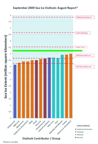
From a post on CA SteveM posted a graph from the NSIDC’s compiled 2008 projections of sea ice by the different ‘experts’ in the field. Since 2008 minimum is clearly marked and 220,000 sq miles is equal to 570,000 sq kilometers of increase. We can determine where on the NSIDC graph the actual Arctic sea ice turned out.
All I can say is, be glad you’re not an expert on sea ice. The linear trend is actually closer than the majority of the experts.

Comments are closed.